|
|
The 2nd
war winter
– Arctic Skagerrak
Back to Homrpage |
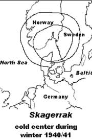
Cold center, Kristiansand, Oslo, Gothenburg
All the facts mentioned above should not be so much of a surprise if one accounts the circumstances properly. Actually, one should deal with three topics: First: Applying same conditions and thoughts as raised and explained for the 1st war winter 1939/40. The 2nd war winter was again very cold but the least cold of the three war winters 1939-1942, due to a simple reason. During autumn and winter 1940/41, the Baltic Sea saw much less naval war activities than during the same time in 1939/40 and 1941/42. In a following section, a brief overview of naval activities and severity of winter 1941/42 throughout North Europe will be given. It will prove, beyond any doubts, that war at sea paved the way for arctic conditions. However, we will focus on the next two topics. Second: Skagerrak and Norwegian coastal seas over a distance of 2000 km from Oslo to Tromsø became a major naval battleground, from May until June 1940, when Germany attacked and occupied Norway, operation known under the codename “Weserübung”. Norway’s fjords and coastal seas remained under anthropogenic stress after June 1940, until arctic conditions had settled in with record low temperatures in January 1941. Third: With a depth of down to 700 meters, Skagerrak basin is a unique area in the seawater structure of North and Baltic Sea. With regard to its depth, there are some minor similarities with the Gulf of Bothnia (max. 294m). But Skagerrak is completely different for a number of other reasons, particularly salinity and current system, which includes substantial water inflow from the Atlantic Ocean. Making war in a sea area where water temperatures are permanently below 6°C, at a depth between about 100m deep and the sea bottom, brings up a new dimension in our “hot soup stirring” theory. Logically, if only the surface is hot and the bottom of the soup cup is cold, churning would decrease temperature at surface, reduce evaporation, reduce ‘giving off steam’, and reduce the release of stored heat. The last two topics are both responsible for causing a record cold winter in the triangle Oslo, Gothenburg and Vyborg area and, therefore, they deserve a more detailed presentation and discussion. An overview of winter 1940/41General conditions of war winter 1940/41 in Northern Europe are easy to explain. Even though the winter was very cold, it did not equal that of 1939/40 (Germany, Holland, Britain) or the third war winter 1941/42, particularly in Sweden and the Netherlands. In Germany, the winter 1940/41 ranked the 20th among about 150; in the Netherlands, it ranked the 33rd among about 150 ‘ice winters’ between 1706 and 1946; and in Sweden it ranked the 23rd among the coldest winters since 1757, while the winter of 1939/40 was the 9th or 10th. All areas close to Skagerrak reached top ranking positions. For Southern Norway, it was established by a number of stations that the lowest temperatures ever measured had been recorded in January 1941. Southern and middle parts of Sweden had been colder than during January 1941 and, in some locations, even colder than in 1860, when most of the meteorological stations in the country had been commissioned. The greatest heat deficit was observed in the inner parts of Götaland and northern Dalarna. Even in Southern Sweden, severe night frost of -20°C and less was observed, which occurs very rarely. Denmark recorded the coldest January since 1874. It is of particular interest that Northern Jutland of Denmark recorded temperatures varying from –20 to –28°C, while Southern Jutland was about six degrees ‘warmer’, recording from –16° to –22° Celsius. The cold centre of the winter 1940/41 was around Skagerrak. Occupation of NorwayWWII had started for just seven months when, in April 1940, Adolf Hitler sent the German Navy on attack missions against Norway. The well-prepared invasion plan “Weserübung” was to take place in one move. A minimum of six locations were targeted, Oslo and Kristiansand (Skagerrak), as well as Stavanger, Bergen, Trontheim, and Narvik, covering a distance of about 2,000 km, with numerous fjords, bights, islands and rocks. During
the campaign which lasted until June 1940, presumably 80 to 120 naval
vessels and ca. 1,000 airplanes had been available in the service of the
parties at war. Although the Norwegian Navy was small, it was able to
lay sea mines with their fleet of a dozen mine layers and to use
installed coastal batteries in a great number of locations. One of the
first battles occurred in the vicinity of Narvik. On the 10th
of April 1940, five Royal Navy destroyers entered the harbour of Narvik,
where five destroyers of the Kriegsmarine were seriously damaged,
thereof two sunk. Six other German ships were also sunk. British Navy
lost two destroyers. Material and ammunition needed by the German forces were to be transported to various locations by about 50 vessels, with a total capacity of 250,000 tons. Loss of ships and tonnage during this campaign amounted to about 20% of the total ships/tonnage available, including two tank ships of 6,000 tons. The Campaign ended on the 10th of June. During the struggle which lasted four months, a total of 34 naval vessels of about 500,000 tons, including 9 submarines, 19 destroyers or bigger ships, were sunk or damaged. The loss of naval vessels was equal on both sides. The struggle between the Allies and the German naval forces continued along Norway’s coast during the remaining months of 1940. British, Dutch and Polish submarines permanently navigated in the area to search and target German convoys and naval vessels. Stirring SkagerrakWhen evaluating any war at sea, we must be aware of the fact that the impact of stirring and churning the seawater body down to a depth of 60-80 meters is nothing compared to the situations which affects lower water masses. Due to a complex current system with quite different water masses coming from different sources, Skagerrak makes it even worst. That is certainly interesting for ocean science but need not interfere with this investigation. Fine-tuned observation may not be needed if experiments are done by brute force. Carrying out war operations in the deep water areas of Skagerrak and along the Norwegian south-western coast is nothing more than a grand climatic adventure. Changed seawater structures will inevitable change winter conditions.
One will never know what actually happened with Skagerrak seawater body in the summer and autumn of 1940. Not only that the data series in deep water layer have never been taken, but a complex current system would also limit computer modelling. But the way naval war has immediate impact on deep water layers can be convincingly demonstrated with reference to another location in Vestfjorden, in the vicinity of Narvik. At Skrova, the Norwegian Fishery Directory took deep-water temperatures from 1937 until 1943, except for the occupation months, in the summer 1940. Below 200 meters water body temperatures no longer react to seasonal variations. From 1937 until the Germans’ ambush, temperature at the depth of 300m run steadily between 6,6°C and 7,2°C. Suddenly, in July 1940, temperatures were more than 1°C lower and remained on a low and steady level until 1943 (between 5,8-6,3°C). Harbour and sea near Narvik saw a number of naval encounters. Skrova data give evidence of deep-reaching effects. Changing deep-sea water layers by one degree is a very serious climatical matter. Naval war between 1939 and 1945 made its impact many million times. Deep, complex and cold Skagerrak, together with many other deep water areas along the Norwegian coast had to bear many hundred thousands of events which changed the temperature (and salinity) structure of water body in the fjords and coastal seas. Taking into account that a forceful current system can fairly exchange Skagerrak water[143], the occupation of Norway may be reflected in severe and early sea icing during the winter of 1940/41, which together with the pervious war winter of 1939/40 became heaviest ice winter in the north of Copenhagen in many decades. However, sea icing caused the earlier start of the winter 1940/41 (more than 14 days earlier than usual), while icing of 1939/40 started later than that. It seems obvious that the replacement of Skagerrak surface water took more time than usual, thus allowing an extreme early start of sea icing in Skagerrak and north Kattegat area. As the war was due to naval activities and weather was colder than during peacetime, an arctic winter could break into the region very early and with brutal force. Summing up Skagerrak Arctic WinterClimatologically, Norway is a maritime country. Weather is highly influenced by the warm Gulf Currents which extends their reach to the Strait of Skagerrak, and by the Norwegian Current flowing northwards, along the coast. In January, Oslo mean air temperatures ran suddenly amok with 2°C lower than the next lowest means during a January without war since 1816, viz. 1867 that accounted –11°C, while January 1941 recorded –13°C, in a city with a long-term January means of –3,5°C. This month of January beats Little Ice Age conditions in the early 19th century and nobody ever wondered why. By all means, the answer is presumably the easiest in the world. During the previous nine months, all water areas and many fjords along the Norwegian coast became the battleground for naval warfare. Naval vessels, bombs and depth charges did not only churned and turned seasonally warmed and cooled surface layer of the water (40-60 meter deep), but also operated along a 200-700 meter deep trench, along the coast of Norway, from Sweden (Gothenburg) to the Atlantic (north of Shetland Islands). Deep water and surface water differ by 10 degrees, even more during peak time, in August/September. Warfare at sea surface can easily ‘restructure’ the thermocline of any water layer below. The Skrova case can illustrate this phenomenon (see above). The cold was not only overwhelming, but it also came very early, which is another sign that sea area troubled by war had little heat reserves in store to sustain statistical expectation. A convincing proof for this causal relation between the war and the cold weather is the fact that all coastal areas around Skagerrak were dragged into exceptional cold conditions with record temperatures never experienced before. This allows only one conclusion: German war machinery (used for Norway’s occupation) and naval warfare are responsible for the cold centre winter of 1940/41 which was established at Skagerrak and which influenced Oslo, Gothenburg and Vyborg with record low temperatures. [139]The second coldest month was January 1942 (-12,1°C); the third coldest month, January 1917 (-11,6), seven months after the Battle of Jutland, monthly means temperatures at Oslo/Gardermoen (www.wetterzentrale.com/klima/) during time period 1816-1988. The 4th coldest month was January 1867 (-11°C), the 5th coldest month, January 1820 (-10,7°C). [140] Hesselberg & Birkeland, see: References; e.g. Eidsberge (-29°C), Rade (-34,6°C), Freder (-14,5°), Torungen (-19°C), Kristiansand (-21,5°C). [141] Det Danske; Det Danske Metorologiske Institut; ‘Is- og besejlingsforholdene i de danske Farvande in Vinteren 1939-40; 1940-41; 1941-42; 1947, Kobenhavn. [142] Bernaerts, Climate Change & Naval War, Victoria/CA 2005, p. 165 [143] Water entering Skagerrak via the Jutland Current in the southwest, proceeding along Denmark’s coast, turning anti clockwise at Sweden’s coast to pass near the Oslo Fjord, the Norwegian Coast Current flowing south-westward until leaving Skagerrak and turning northwards and flowing along Norway’s coast until reaching Norwegian Sea. In opposite direction a deep counter current injects highly saline Atlantic water into the Skagerrak depths. |
|